


Berlin Metro (U-Bahn) Map 2024
Description of Berlin Metro (U-Bahn) Map 2024
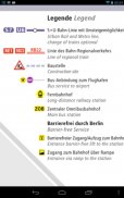
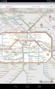
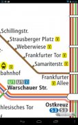
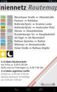
Berlin Metro (U-Bahn) Map - a simple free and offline map, very useful for tourists and visitors.
The Berlin U-Bahn (from "Untergrundbahn", meaning "underground railway") is a rapid transit railway in Berlin, the capital city of Germany, and is a major part of the public transport system of the city. Opened in 1902, the U-Bahn serves 173 stations spread across ten lines, with a total track length of 146.3 kilometres (90.9 mi), about 80% of which is underground. Trains run every two to five minutes during peak hours, every five minutes for the rest of the day and every ten minutes in the evening. They travel 20.9 million km (13 million mi), carrying 496 million passengers, over the year. The entire system is maintained and operated by the Berliner Verkehrsbetriebe, commonly known as the BVG.
Designed to alleviate traffic flowing into and out of central Berlin, the U-Bahn rapidly expanded until the city was divided into East and West Berlin at the end of World War II. Although the system initially remained open to residents of both sides, the construction of the Berlin Wall and the subsequent restrictions imposed by the East German government limited travel across the border: The East Berlin U-Bahn lines were severed from West Berlin; while two West Berlin lines that ran through East Berlin (U6 and U8) were allowed to pass through without stopping, although the stations were closed, with the exception of Friedrichstraße, used as a transfer point (between U6 and the West Berlin S-Bahn system) and a border crossing into East Berlin. The system was reopened completely following the fall of the Berlin Wall, and German reunification.
As of 2007, the Berlin U-Bahn is the most extensive underground network in Germany. True to its original goal, it has been calculated that, in 2006, use of the U-Bahn amounted to the equivalent of 122.2 million km (76 million mi) of car journeys. Together with the S-Bahn, it serves as the main means of transport of the capital and in addition the Tram operates in the eastern parts of the city.
Berlin Metro (U-Bahn) Map 2024 - APK Information
APK Version: 3.3Package: com.ilicit.berlin.metro.hdLatest Version of Berlin Metro (U-Bahn) Map 2024
Other versions


Apps in the same category

You may also like...


